Name   | Jahr | Signatur | Maßstab | | Woltersdorf (Woltersdorff) Amt/Distrikt Oder/Randow
| 1740 [Orig. 1697] | AI 101 | 1:8.333 | 
weitere Formate verfügbar |
| Sammlung: | Matrikelkarten der Landesaufnahme von Schwedisch-Pommern | | Beschreibung | | Signatur: | AI 101 | | Titel: | Woltersdorf (Woltersdorff) Amt/Distrikt Oder/Randow | | Autor: | Dr. Plönnies | | Referenzdatum: | 1740 [Orig. 1697] (Erzeugung) | | Geographische Ausdehnung: | Germany | | Zeitliche Ausdehnung (historische Karten): | 1697 - 1740 | | Thematik: | Matrikelkarten | | Online-Ressource |  | Karte anzeigen: AI101.jpg | | | Karte anzeigen: AI101.djvu | | Zugriff | Anwendungs-
einschränkungen: | Die Nutzung dieser Aufnahme für Forschung, Lehre und Privatgebrauch ist gestattet. Gewerbliche Nutzung, Reproduktion und Veröffentlichung nur mit schriftlicher Genehmigung des Landesarchivs Greifswald. | | Räumliche Auflösung | | Maßstab: | 1: 8.333 | | Herkunft: | Landesarchiv Greifswald | | Metadaten | | Datumsstempel | 2021-08-20 13:28:29 |
|
Wolthof (Wolthoff) Amt/Distrikt Loitz
| | BIV 38 | 1:8.333 |
weitere Formate verfügbar |
| Sammlung: | Matrikelkarten der Landesaufnahme von Schwedisch-Pommern | | Beschreibung | | Signatur: | BIV 38 | | Titel: | Wolthof (Wolthoff) Amt/Distrikt Loitz | | Geographische Ausdehnung: | Germany | | Thematik: | Matrikelkarten | | Online-Ressource | | | Karte anzeigen: BIV38.jpg | | | Karte anzeigen: BIV38.djvu | | | | Zugriff | Anwendungs-
einschränkungen: | Die Nutzung dieser Aufnahme für Forschung, Lehre und Privatgebrauch ist gestattet. Gewerbliche Nutzung, Reproduktion und Veröffentlichung nur mit schriftlicher Genehmigung des Landesarchivs Greifswald. | | Räumliche Auflösung | | Maßstab: | 1: 8.333 | | Herkunft: | Landesarchiv Greifswald | | Metadaten | | Datumsstempel | 2021-08-20 13:28:29 |
|
Wolthof (Wolthoff) Amt/Distrikt Loitz
| | AIV a 30 | 1:8.333 |
weitere Formate verfügbar |
| Sammlung: | Matrikelkarten der Landesaufnahme von Schwedisch-Pommern | | Beschreibung | | Signatur: | AIV a 30 | | Titel: | Wolthof (Wolthoff) Amt/Distrikt Loitz | | Geographische Ausdehnung: | Germany | | Thematik: | Matrikelkarten | | Online-Ressource | | | Karte anzeigen: AIVa30.jpg | | | Karte anzeigen: AIVa30.djvu | | Zugriff | Anwendungs-
einschränkungen: | Die Nutzung dieser Aufnahme für Forschung, Lehre und Privatgebrauch ist gestattet. Gewerbliche Nutzung, Reproduktion und Veröffentlichung nur mit schriftlicher Genehmigung des Landesarchivs Greifswald. | | Räumliche Auflösung | | Maßstab: | 1: 8.333 | | Herkunft: | Landesarchiv Greifswald | | Metadaten | | Datumsstempel | 2021-08-20 13:28:29 |
|
Wrangelsburg (Wrangelsborg) Amt/Distrikt Wolgast
| 1694 | BI 23 | 1:8.333 |
weitere Formate verfügbar |
| Sammlung: | Matrikelkarten der Landesaufnahme von Schwedisch-Pommern | | Beschreibung | | Signatur: | BI 23 | | Titel: | Wrangelsburg (Wrangelsborg) Amt/Distrikt Wolgast | | Autor: | Brynolph (Bryniel) Hesselgreen | | Referenzdatum: | 1694 (Erzeugung) | | Geographische Ausdehnung: | Germany | | Zeitliche Ausdehnung (historische Karten): | 1694 - 1694 | | Thematik: | Matrikelkarten | | Online-Ressource | | | Karte anzeigen: BI23.jpg | | | Karte anzeigen: BI23.djvu | | Karte anzeigen in SVEA-Pommern | | Zugriff | Anwendungs-
einschränkungen: | Die Nutzung dieser Aufnahme für Forschung, Lehre und Privatgebrauch ist gestattet. Gewerbliche Nutzung, Reproduktion und Veröffentlichung nur mit schriftlicher Genehmigung des Landesarchivs Greifswald. | | Räumliche Auflösung | | Maßstab: | 1: 8.333 | | Herkunft: | Landesarchiv Greifswald | | Metadaten | | Datumsstempel | 2021-08-20 13:28:29 |
|
Wrangelsburg (Wrangelsborg) Amt/Distrikt Wolgast
| | AII 28 | 1:8.333 |
weitere Formate verfügbar |
|
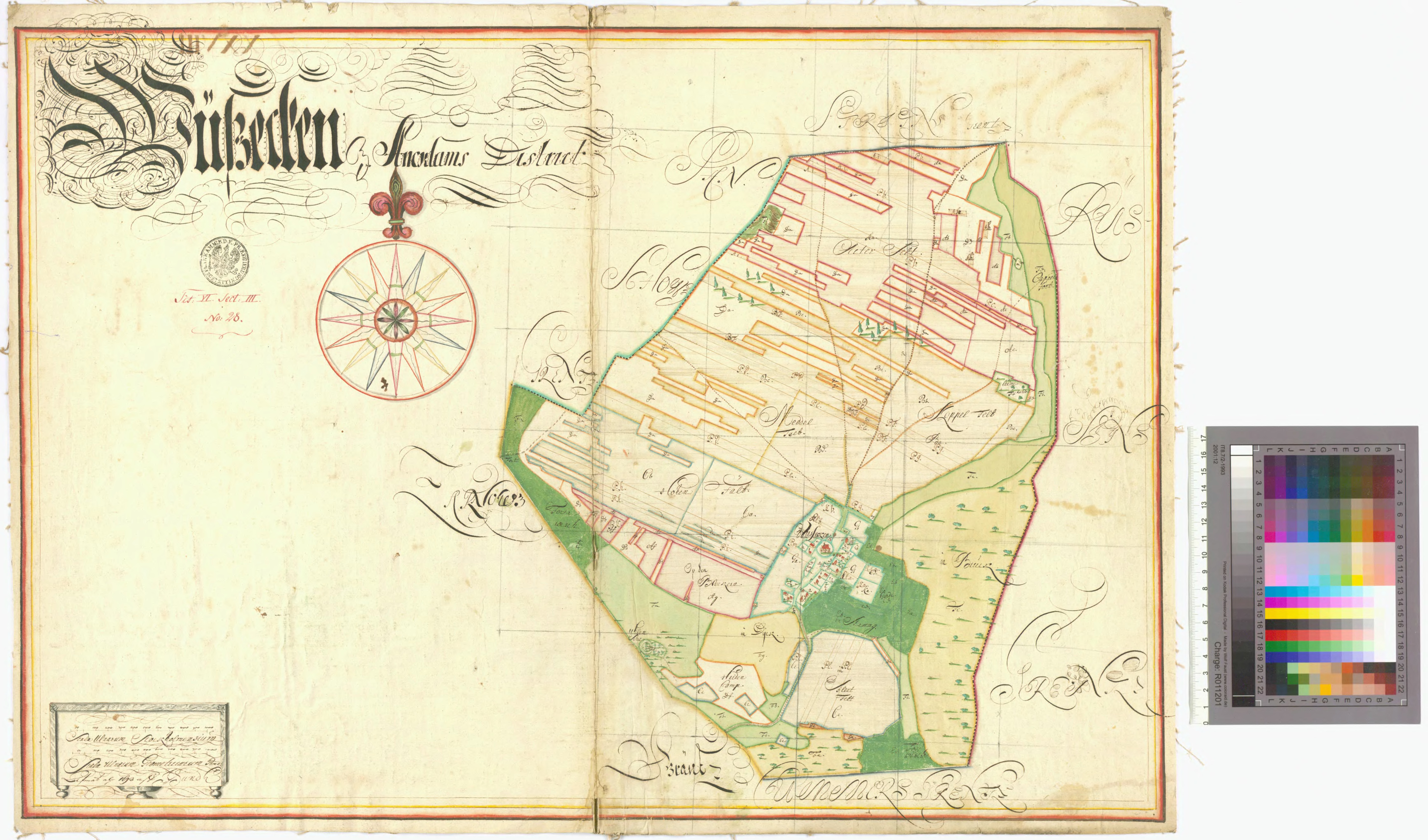
Wusseken (Wusseken, Wotzeken) Amt/Distrikt Anklam
| | AIII b 26 | 1:8.333 |
weitere Formate verfügbar |
| Sammlung: | Matrikelkarten der Landesaufnahme von Schwedisch-Pommern | | Beschreibung | | Signatur: | AIII b 26 | | Titel: | Wusseken (Wusseken, Wotzeken) Amt/Distrikt Anklam | | Geographische Ausdehnung: | Germany | | Thematik: | Matrikelkarten | | Online-Ressource | | | Karte anzeigen: AIIIb26.jpg | | | Karte anzeigen: AIIIb26.djvu | | Zugriff | Anwendungs-
einschränkungen: | Die Nutzung dieser Aufnahme für Forschung, Lehre und Privatgebrauch ist gestattet. Gewerbliche Nutzung, Reproduktion und Veröffentlichung nur mit schriftlicher Genehmigung des Landesarchivs Greifswald. | | Räumliche Auflösung | | Maßstab: | 1: 8.333 | | Herkunft: | Landesarchiv Greifswald | | Metadaten | | Datumsstempel | 2021-08-20 13:28:29 |
|
Wusseken (Wusseken, Wotzeken) Amt/Distrikt Anklam
| 1698 | CIII a 28 | 1:8.333 |
weitere Formate verfügbar |
| Sammlung: | Matrikelkarten der Landesaufnahme von Schwedisch-Pommern | | Beschreibung | | Signatur: | CIII a 28 | | Titel: | Wusseken (Wusseken, Wotzeken) Amt/Distrikt Anklam | | Autor: | Jonas Sundh | | Referenzdatum: | 1698 (Erzeugung) | | Geographische Ausdehnung: | Germany | | Zeitliche Ausdehnung (historische Karten): | 1698 - 1698 | | Thematik: | Matrikelkarten | | Online-Ressource | | | Karte anzeigen: CIIIa28.jpg | | | Karte anzeigen: CIIIa28.djvu | | Zugriff | Anwendungs-
einschränkungen: | Die Nutzung dieser Aufnahme für Forschung, Lehre und Privatgebrauch ist gestattet. Gewerbliche Nutzung, Reproduktion und Veröffentlichung nur mit schriftlicher Genehmigung des Landesarchivs Greifswald. | | Räumliche Auflösung | | Maßstab: | 1: 8.333 | | Herkunft: | Landesarchiv Greifswald | | Metadaten | | Datumsstempel | 2021-08-20 13:28:29 |
|
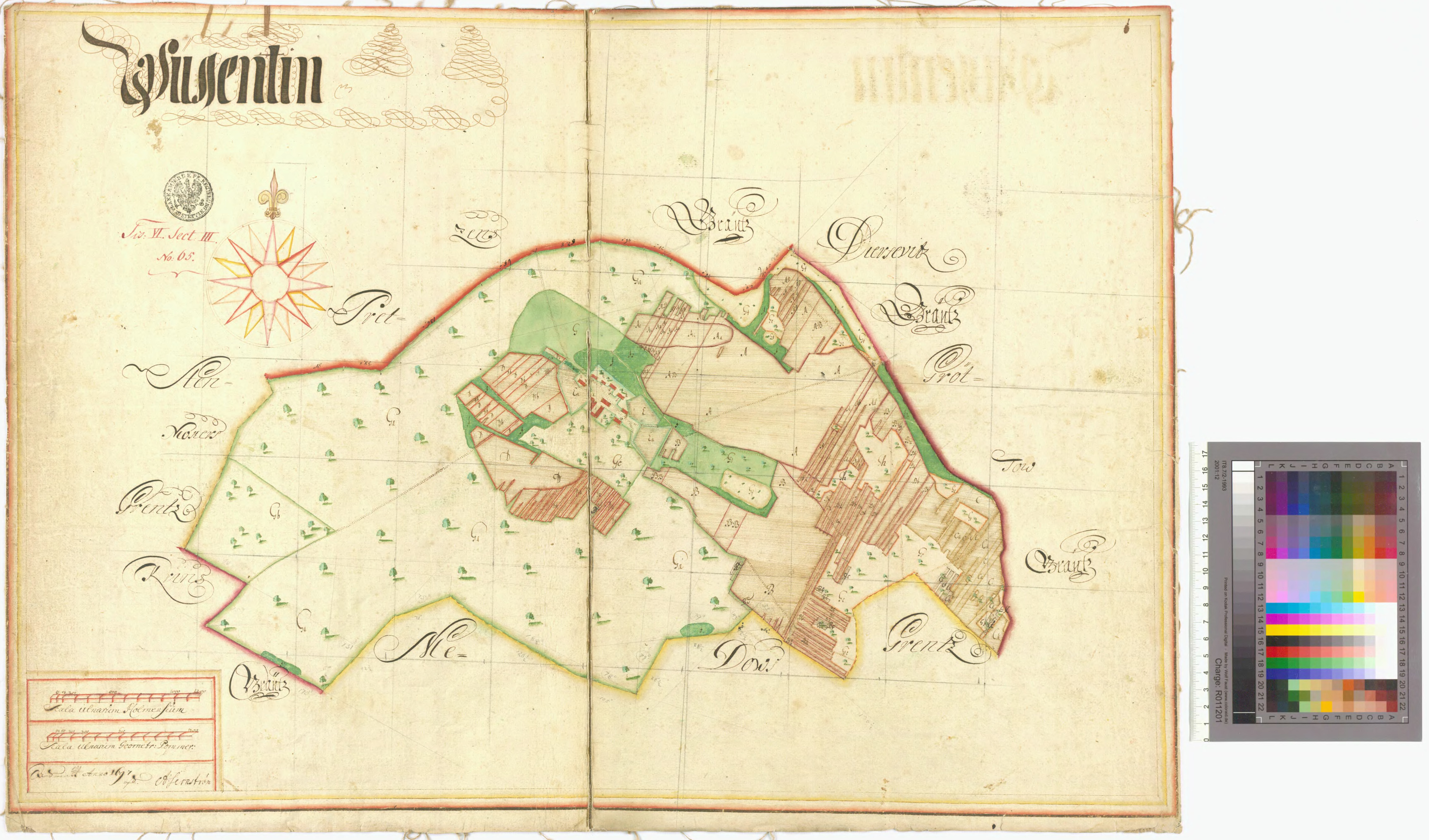
Wussentin (Wussenthin) Amt/Distrikt Stolpe
| 1697 | CIII b 65 | 1:8.333 |
weitere Formate verfügbar |
| Sammlung: | Matrikelkarten der Landesaufnahme von Schwedisch-Pommern | | Beschreibung | | Signatur: | CIII b 65 | | Titel: | Wussentin (Wussenthin) Amt/Distrikt Stolpe | | Autor: | Anders Jernström | | Referenzdatum: | 1697 (Erzeugung) | | Geographische Ausdehnung: | Germany | | Zeitliche Ausdehnung (historische Karten): | 1697 - 1697 | | Thematik: | Matrikelkarten | | Online-Ressource | | | Karte anzeigen: CIIIb65.jpg | | | Karte anzeigen: CIIIb65.djvu | | Zugriff | Anwendungs-
einschränkungen: | Die Nutzung dieser Aufnahme für Forschung, Lehre und Privatgebrauch ist gestattet. Gewerbliche Nutzung, Reproduktion und Veröffentlichung nur mit schriftlicher Genehmigung des Landesarchivs Greifswald. | | Räumliche Auflösung | | Maßstab: | 1: 8.333 | | Herkunft: | Landesarchiv Greifswald | | Metadaten | | Datumsstempel | 2021-08-20 13:28:29 |
|
Wussow Amt/Distrikt Stettin
| 1693 | CVI b 20 | 1:8.333 |
weitere Formate verfügbar |
| Sammlung: | Matrikelkarten der Landesaufnahme von Schwedisch-Pommern | | Beschreibung | | Signatur: | CVI b 20 | | Titel: | Wussow Amt/Distrikt Stettin | | Autor: | Arvid Carlmark | | Referenzdatum: | 1693 (Erzeugung) | | Geographische Ausdehnung: | Germany | | Zeitliche Ausdehnung (historische Karten): | 1693 - 1693 | | Thematik: | Matrikelkarten | | Online-Ressource | | | Karte anzeigen: CVIb20.jpg | | | Karte anzeigen: CVIb20.djvu | | Zugriff | Anwendungs-
einschränkungen: | Die Nutzung dieser Aufnahme für Forschung, Lehre und Privatgebrauch ist gestattet. Gewerbliche Nutzung, Reproduktion und Veröffentlichung nur mit schriftlicher Genehmigung des Landesarchivs Greifswald. | | Räumliche Auflösung | | Maßstab: | 1: 8.333 | | Herkunft: | Landesarchiv Greifswald | | Metadaten | | Datumsstempel | 2021-08-20 13:28:29 |
|
Wussow Amt/Distrikt Stettin
| | AI 7 | 1:8.333 |
weitere Formate verfügbar |
| Sammlung: | Matrikelkarten der Landesaufnahme von Schwedisch-Pommern | | Beschreibung | | Signatur: | AI 7 | | Titel: | Wussow Amt/Distrikt Stettin | | Geographische Ausdehnung: | Germany | | Thematik: | Matrikelkarten | | Online-Ressource | | | Karte anzeigen: AI7.jpg | | | Karte anzeigen: AI7.djvu | | Zugriff | Anwendungs-
einschränkungen: | Die Nutzung dieser Aufnahme für Forschung, Lehre und Privatgebrauch ist gestattet. Gewerbliche Nutzung, Reproduktion und Veröffentlichung nur mit schriftlicher Genehmigung des Landesarchivs Greifswald. | | Räumliche Auflösung | | Maßstab: | 1: 8.333 | | Herkunft: | Landesarchiv Greifswald | | Metadaten | | Datumsstempel | 2021-08-20 13:28:29 |
|
Zabelsdorf (Zabelsdorff) Amt/Distrikt Stettin
| 1692 | CVI b 35 | 1:8.333 |
weitere Formate verfügbar |
| Sammlung: | Matrikelkarten der Landesaufnahme von Schwedisch-Pommern | | Beschreibung | | Signatur: | CVI b 35 | | Titel: | Zabelsdorf (Zabelsdorff) Amt/Distrikt Stettin | | Autor: | Simon Skragge, Oloff (Olaus) Spaak | | Referenzdatum: | 1692 (Erzeugung) | | Geographische Ausdehnung: | Germany | | Zeitliche Ausdehnung (historische Karten): | 1692 - 1692 | | Thematik: | Matrikelkarten | | Online-Ressource | | | Karte anzeigen: CVIb35.jpg | | | Karte anzeigen: CVIb35.djvu | | Zugriff | Anwendungs-
einschränkungen: | Die Nutzung dieser Aufnahme für Forschung, Lehre und Privatgebrauch ist gestattet. Gewerbliche Nutzung, Reproduktion und Veröffentlichung nur mit schriftlicher Genehmigung des Landesarchivs Greifswald. | | Räumliche Auflösung | | Maßstab: | 1: 8.333 | | Herkunft: | Landesarchiv Greifswald | | Metadaten | | Datumsstempel | 2021-08-20 13:28:29 |
|
Zandershagen Amt/Distrikt Franzburg
| | BVIII 106 | 1:8.333 |
weitere Formate verfügbar |
| Sammlung: | Matrikelkarten der Landesaufnahme von Schwedisch-Pommern | | Beschreibung | | Signatur: | BVIII 106 | | Titel: | Zandershagen Amt/Distrikt Franzburg | | Geographische Ausdehnung: | Germany | | Thematik: | Matrikelkarten | | Online-Ressource | | | Karte anzeigen: BVIII106.jpg | | | Karte anzeigen: BVIII106.djvu | | Zugriff | Anwendungs-
einschränkungen: | Die Nutzung dieser Aufnahme für Forschung, Lehre und Privatgebrauch ist gestattet. Gewerbliche Nutzung, Reproduktion und Veröffentlichung nur mit schriftlicher Genehmigung des Landesarchivs Greifswald. | | Räumliche Auflösung | | Maßstab: | 1: 8.333 | | Herkunft: | Landesarchiv Greifswald | | Metadaten | | Datumsstempel | 2021-08-20 13:28:29 |
|
Zarnekla (Zarneklow) Amt/Distrikt Loitz
| 1697 | BIV 33 | 1:8.333 |
weitere Formate verfügbar |
| Sammlung: | Matrikelkarten der Landesaufnahme von Schwedisch-Pommern | | Beschreibung | | Signatur: | BIV 33 | | Titel: | Zarnekla (Zarneklow) Amt/Distrikt Loitz | | Autor: | Johan Petersen | | Referenzdatum: | 1697 (Erzeugung) | | Geographische Ausdehnung: | Germany | | Zeitliche Ausdehnung (historische Karten): | 1697 - 1697 | | Thematik: | Matrikelkarten | | Online-Ressource | | | Karte anzeigen: BIV33.jpg | | | Karte anzeigen: BIV33.djvu | | Zugriff | Anwendungs-
einschränkungen: | Die Nutzung dieser Aufnahme für Forschung, Lehre und Privatgebrauch ist gestattet. Gewerbliche Nutzung, Reproduktion und Veröffentlichung nur mit schriftlicher Genehmigung des Landesarchivs Greifswald. | | Räumliche Auflösung | | Maßstab: | 1: 8.333 | | Herkunft: | Landesarchiv Greifswald | | Metadaten | | Datumsstempel | 2021-08-20 13:28:29 |
|
Zarnekla (Zarneklow) Amt/Distrikt Loitz
| | AIV a 28 | 1:8.333 |
weitere Formate verfügbar |
| Sammlung: | Matrikelkarten der Landesaufnahme von Schwedisch-Pommern | | Beschreibung | | Signatur: | AIV a 28 | | Titel: | Zarnekla (Zarneklow) Amt/Distrikt Loitz | | Geographische Ausdehnung: | Germany | | Thematik: | Matrikelkarten | | Online-Ressource | | | Karte anzeigen: AIVa28.jpg | | | Karte anzeigen: AIVa28.djvu | | Zugriff | Anwendungs-
einschränkungen: | Die Nutzung dieser Aufnahme für Forschung, Lehre und Privatgebrauch ist gestattet. Gewerbliche Nutzung, Reproduktion und Veröffentlichung nur mit schriftlicher Genehmigung des Landesarchivs Greifswald. | | Räumliche Auflösung | | Maßstab: | 1: 8.333 | | Herkunft: | Landesarchiv Greifswald | | Metadaten | | Datumsstempel | 2021-08-20 13:28:29 |
|
Zarnitz Amt/Distrikt Wolgast
| 1694 | BI 14 | 1:8.333 |
weitere Formate verfügbar |
| Sammlung: | Matrikelkarten der Landesaufnahme von Schwedisch-Pommern | | Beschreibung | | Signatur: | BI 14 | | Titel: | Zarnitz Amt/Distrikt Wolgast | | Autor: | Arvid Carlmark | | Referenzdatum: | 1694 (Erzeugung) | | Geographische Ausdehnung: | Germany | | Zeitliche Ausdehnung (historische Karten): | 1694 - 1694 | | Thematik: | Matrikelkarten | | Online-Ressource | | | Karte anzeigen: BI14.jpg | | | Karte anzeigen: BI14.djvu | | Karte anzeigen in SVEA-Pommern | | Zugriff | Anwendungs-
einschränkungen: | Die Nutzung dieser Aufnahme für Forschung, Lehre und Privatgebrauch ist gestattet. Gewerbliche Nutzung, Reproduktion und Veröffentlichung nur mit schriftlicher Genehmigung des Landesarchivs Greifswald. | | Räumliche Auflösung | | Maßstab: | 1: 8.333 | | Herkunft: | Landesarchiv Greifswald | | Metadaten | | Datumsstempel | 2021-08-20 13:28:29 |
|
Zarrentin Amt/Distrikt Loitz
| | BV 70 | 1:8.333 |
weitere Formate verfügbar |
|
Zarrentin Amt/Distrikt Loitz
| | AIV a 54 | 1:8.333 |
weitere Formate verfügbar |
|
Zarrentin Amt/Distrikt Tribsees
| 1696 | BIV 7 | 1:8.333 |
weitere Formate verfügbar |
| Sammlung: | Matrikelkarten der Landesaufnahme von Schwedisch-Pommern | | Beschreibung | | Signatur: | BIV 7 | | Titel: | Zarrentin Amt/Distrikt Tribsees | | Autor: | Oloff (Olaus) Spaak | | Referenzdatum: | 1696 (Erzeugung) | | Geographische Ausdehnung: | Germany | | Zeitliche Ausdehnung (historische Karten): | 1696 - 1696 | | Thematik: | Matrikelkarten | | Online-Ressource | | | Karte anzeigen: BIV7.jpg | | | Karte anzeigen: BIV7.djvu | | Karte anzeigen in SVEA-Pommern | | Zugriff | Anwendungs-
einschränkungen: | Die Nutzung dieser Aufnahme für Forschung, Lehre und Privatgebrauch ist gestattet. Gewerbliche Nutzung, Reproduktion und Veröffentlichung nur mit schriftlicher Genehmigung des Landesarchivs Greifswald. | | Räumliche Auflösung | | Maßstab: | 1: 8.333 | | Herkunft: | Landesarchiv Greifswald | | Metadaten | | Datumsstempel | 2021-08-20 13:28:29 |
|
Zarrentin Amt/Distrikt Tribsees
| | AIV a 6 | 1:8.333 |
weitere Formate verfügbar |
|
Zünz Amt/Distrikt Wollin
| | CII b 28 | 1:8.333 |
weitere Formate verfügbar |
| Sammlung: | Matrikelkarten der Landesaufnahme von Schwedisch-Pommern | | Beschreibung | | Signatur: | CII b 28 | | Titel: | Zünz Amt/Distrikt Wollin | | Geographische Ausdehnung: | Germany | | Thematik: | Matrikelkarten | | Online-Ressource | | | Karte anzeigen: CIIb28.jpg | | | Karte anzeigen: CIIb28.djvu | | Zugriff | Anwendungs-
einschränkungen: | Die Nutzung dieser Aufnahme für Forschung, Lehre und Privatgebrauch ist gestattet. Gewerbliche Nutzung, Reproduktion und Veröffentlichung nur mit schriftlicher Genehmigung des Landesarchivs Greifswald. | | Räumliche Auflösung | | Maßstab: | 1: 8.333 | | Herkunft: | Landesarchiv Greifswald | | Metadaten | | Datumsstempel | 2021-08-20 13:28:29 |
|